
Category: Dear Grumpy Advice on Teaching in Today’s Classroom
https://youtu.be/gfqeDVXyy0c

World War II is over and instead of the expected Depression. America enters into a Golden Age for most of its Citizens! God how green with envy am I! Grumpy
General George S. Patton – A Vision for Business Leadership
https://youtu.be/lfqIa4dDxrw
A Civil War Confederate Soldier. Julius Franklin Howell, at the age of sixteen, entered Confederate service and would in time become a member of the 24th Virginia Cavalry.
On occasions, he was on detached duty, serving general officers as a trusted courier. In the waning days of the war he was captured and imprisoned until after the war’s end. In the post-war years the Confederate veteran became a well-regarded educator.
He remained invested in the preservation of the memories of the Confederate soldier, and his title of General was obtained from his tenure as the Commander-in-Chief of the United Confederate Veterans.
Howell’s long and useful life spanned more than a century, and when he died at the age of 102, he was purported to have been the final survivor of General James Longstreet’s Corps.


U.S.A. –-(Ammoland.com)- Buried near the end of a 916-word Op-ed for Fox News discussing the recent walkout of students and parents at a vigil-turned-gun-control-event, writer and best-selling author Frank Miniter drives a rhetorical wooden stake deep into the heart of the media’s bias against guns and people who own them.
“Political differences aside,” Miniter proffers, “imagine if the media actually treated gun rights groups honestly.”
Indeed. Imagine that.
For decades, gun owners and especially Second Amendment activists have complained about media bias. Editorials demanding increasingly restrictive gun control laws are one thing, but when – as many rights activists have asserted – bias finds its way into news columns, that’s a problem.
Miniter, who admits to writing a weekly gun-rights column for the NRA, reported on the walkout at the evening vigil for students who were shot by two of their own classmates at Colorado’s STEM School Highlands Ranch. Students and their parents were appalled and angered when visiting politicians tried to exploit the event to push a gun control agenda.
The event was admittedly sponsored by a Brady Campaign youth group called “Team Enough.” But, as Miniter painfully pointed out, “The very public scene of hundreds of Colorado students and their parents walking out of a vigil that was turned into a political theater by the Brady Campaign to Prevent Gun Violence was so embarrassing that the gun control group actually issued an apology.”
In a statement, the Brady Campaign said, “We are deeply sorry any part of this vigil did not provide the support, caring and sense of community we sought to foster and facilitate and which we know is so crucial to communities who suffer the trauma of gun violence.”
But Alan Gottlieb, chairman of the Citizens Committee for the Right to Keep and Bear Arms, wasn’t buying it. In a prepared statement, Gottlieb chastised the gun prohibition lobbying group, suggesting that Brady owes an apology not just to the students and parents, but to every law-abiding gun owner in America.
“The Brady Campaign was well aware that an anti-gun politician would turn such a somber event into a gun control rally,” he said. “Instead, students and their parents were rightly offended and they responded appropriately by walking out.
“The Brady Campaign and the politicians who tried to exploit this tragedy should be ashamed,” he added.
But what about the media? Should they be ashamed as well?
By incorporating volatile terms including “gun violence” and “high-powered assault weapons” into their reporting, are the media telling a story or selling a particular viewpoint?
When some deranged individual stabs people, why isn’t that reported as “knife violence?” Does anyone in a typical newsroom know that common deer hunting rifles use ammunition that is far more powerful than ammunition used in a typical 5.56mm NATO semi-auto modern sporting rifle?
When was the last time a newspaper or broadcast report identified the National Rifle Association, which has tens of thousands of certified volunteer firearms safety instructors in its ranks, as a “gun safety group?” That designation is typically used in reference to gun control organizations such as the Brady Campaign, Everytown for Gun Safety or Moms Demand Action on Gun Sense in America.
When was the last time a “mainstream” news agency challenged a statement from an anti-gun politician or gun prohibition lobbying group about the failure of laws they have previously pushed when they haven’t prevented violent crimes? When, after a tragedy like the Colorado school shooting, anti-gunners call for background checks, why doesn’t some enterprising reporter or editorial writer ask, “Well, they used a stolen gun. How would a background check have prevented that?” Or, “This suspect had no criminal record, so he passed a background check. How would your proposal have prevented this tragedy?”
Miniter makes some uncomfortable points in his essay, including this one: “The National Rifle Association…has the School Shield program that sends teams of experts to schools to help them create safer environments…The National Shooting Sports Foundation (NSSF), the trade association for firearms manufacturers, has lobbied for FixNICS and many other initiatives to keep guns out of the hands of those who are prohibited from owning them.
“Instead of demonizing these groups,” Miniter contends, “imagine if the mainstream media were willing to be more factual and nuanced in their reporting. Solutions would become much clearer in such a climate.”
Miniter once profiled this writer in a 2017 piece for Forbes, in which he criticized the Washington Post for not having even one “politically incorrect, gun-owning nonconformist in their newsroom. They once had Stephen Hunter on staff, but he is a rare thing indeed.”
While the NRA leadership currently appears to have its share of troubles, it is one of those “rare things” for NRA-sponsored firearms safety programs to enjoy any publicity.
Miniter is not the only notable to blister media bias. Researcher John Lott has done the same, such as in this piece he wrote last year for the Washington Times.
While it may be difficult to imagine gun rights groups ever getting a completely fair shake, especially on editorial pages, Miniter does offer some hope.
“The students who boldly walked out en masse as they chanted ‘mental health, mental health’ from what shouldn’t have been a political event did shock the mainstream media into actually reporting on the story,” he noted about the Colorado flap. “That’s a big step toward finding honest solutions to a horrifying problem.”
About Dave Workman
Dave Workman is a senior editor at TheGunMag.com and Liberty Park Press, author of multiple books on the Right to Keep & Bear Arms and formerly an NRA-certified firearms instructor.
| August 27, 2015
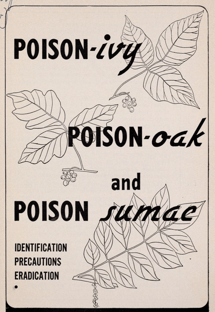
How to Recognize Poison Ivy, Oak, & Sumac and Treat Their Rashes
A stroll in the woods is nearly always an enjoyable endeavor; what’s not so enjoyable is discovering a red, itchy rash the next day. Each year, millions of Americans come in contact with poison ivy, poison oak, or poison sumac. While there are numerous other poisonous plants, these three are grouped together because they share a common irritant: an oily resin/sap called urushiol. This resin is potent — it only takes 1 nanogram to cause a reaction. And unfortunately, it coats all parts of these plants.
While some of the characteristics we describe below aren’t necessarily unique to these plants, we’ll get you enough information to avoid these poisonous foes and confidently walk your favorite trails (or create your own!).
Identifying Poison Ivy
The old saying is true: “Leaves of three, let them be!” While there are other plants which have leaf clusters in threes, both poison ivy and poison oak share this trait, making it best to avoid plants with this feature altogether. What you’ll most likely encounter with poison ivy is a stem with a larger leaf at the end, and two smaller leaves shooting off the sides. The leaves can be notched or smooth on the edges, and they have pointed tips. The plant is reddish in the spring, green in summer, and yellow/orange in the fall. It’s not uncommon to see clusters of greenish-white berries on poison ivy through the spring and summer, as well as green/yellow flowers.


Poison ivy can take the form of a vine or a shrub. The plant’s appearance varies widely based on the region and specific environment where it grows, which is everywhere in the US with the exceptions of Hawaii, Alaska, and parts of the southwest deserts.
Identifying Poison Oak
Like poison ivy, this plant most often grows leaves in clusters of three, although some varieties display five or seven per cluster. The defining feature is that the leaves have a lobed, wavy appearance (also described as scalloped), similar to oak tree leaves, but more subdued. Another characteristic that sets it apart from poison ivy is that the tips of the leaves are rounded rather than pointed. Its leaves are bright green in spring, turn yellow-green or pink in summer, and finally turn yellow into dark brown in the fall.


Poison oak is generally a shrub, averaging about 3 feet tall, but shoots of it can also grow as a vine. Not commonly found in the middle part of the U.S., poison oak is primarily situated on the West coast, and the East coast/Southeast.
Identifying Poison Sumac
Poison sumac stems (which are generally red — another of the defining features) have 7-13 leaves, in pairs, with a lone leaf at the end. Leaves are oval, elongated, and smooth-edged, usually 2-4 inches long. They are bright orange in spring, dark green in summer, and red-orange in fall.


Poison sumac thrives in watery, swampy environs, present mostly in the Midwest and Southeastern U.S., where high humidity is common. It grows as a tree or tall shrub, 5-20 feet tall.
Allergic Reactions to Poison Ivy, Oak, or Sumac
An allergic reaction to poison ivy, oak, or sumac can occur when your skin makes direct contact with the plant, when you touch something that has been in contact with the plant, and even when the plant is burned, as particles of urushiol can make their way into your eyes, nose, and throat. Urushiol is very sticky and tenacious, so it easily adheres to firewood, dog fur, and gardening tools, and then transfers itself to your skin once you lift, pet, and pick up these things. Because urushiol is present in the plants’ roots, stems, and leaves, it remains potentially poisonous even in the wintertime.
Anyone can get an allergic reaction if exposed to urushiol in a large enough dose. But some folks are more sensitive than others. About 85% of the population is fairly to extremely susceptible to getting an allergic reaction, while 15% of lucky folks are resistant to reaction. One’s sensitivity/resistance is thought to be largely genetic in origin, so if your parents have had severe reactions to poisonous plants, take extra care to avoid contact yourself.
Sometimes you only get a rash after being exposed to the plant numerous times. So don’t automatically assume that you’re resistant because you touched poison ivy/oak/sumac once, and didn’t get a rash.
On the other hand, sensitivity to these poisonous plants can lessen over time. So if you had a bad reaction as a child, you may have developed more resistance over the years.
How to Treat a Rash From Poison Ivy, Oak, or Sumac
If you know you’ve touched one of these poisonous plants, you have about 10 minutes before the sap penetrates the lower layers of your skin and binds to its cells, at which point an allergic reaction will set in. So you can head off this reaction by immediately rinsing the exposed area with running water. Use a mild detergent soap if you have it; fatty soaps can spread the urushiol oil, creating a worse reaction. Rinsing with rubbing alcohol is also effective. If wipes are all you have to clean the area, that’s better than nothing.
If you don’t wash off the resin in time, and you’re sensitive to ivy/oak/sumac, then a rash will develop. Rashes from all three of these plants appear in the same form and are treated in the same way since the irritating agent in all of them is urushiol. If you’ve been outdoors and have the following symptoms appear, you may have a rash from one of these plants:
- patches of swollen redness
- outbreak of blisters
- intense itching
These are the primary symptoms, and they generally appear within 12-72 hours of contact. Luckily, if the rash isn’t severe, it can be treated at home without having to see a dermatologist.
The American Academy of Dermatology recommends the following treatment plan:
- Immediately rinse your skin with lukewarm, soapy water. Urushiol is an oil, so if not washed off, it can continue to spread. (Note: there are special washes out there that claim to remove urushiol more effectively and to lesson the severity of a rash once a reaction has set in; Zanfel is a popular one, but Mean Green Scrub uses the same ingredients/composition but costs way less per ounce.)
- Wash your clothing and anything else the oil may have touched, including tools, pets, car seats, etc.
- Do not scratch; doing so can open the skin and possibly cause an infection.
- Leave blisters alone; do not peel overlying skin, as it protects the wound underneath from infection.
- Apply calamine lotion or hydrocortisone cream/lotion.
- Apply a cool washcloth to skin to ease burning and itching.
The rash should heal in about 1-2 weeks. Though it may look gross, it’s not contagious. If the rash is particularly large or painful, or doesn’t heal in that timeframe, it’s best to see a dermatologist who may prescribe a round of oral steroids or other treatments.
Above all, wearing long clothing when you go out is recommended — especially pants to guard against brushing these plants while wandering around. Be sure to wash these clothes right when you get home.
You’re now equipped to head out to the woods and avoid these itchy fiends!